
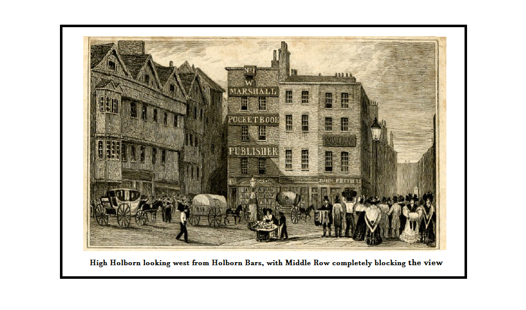
In days of yore, London had some spectacular pinch points hindering the free flow of traffic. These often involved the heavily-used City gates, perhaps the most famous being Temple Bar which, despite its narrow archway, was saved from removal for so long by its high-quality-probably-by-Wren architecture. No such excuse can be made for the longevity of Middle Row, which stood in the middle of a road only yards outside another City entrance, Holborn Bars. Local residents started grumbling in the 1650s that it hampered the free flow of traffic, but two centuries would pass before it finally fell to the demolition crew’s pickaxes.
Setting the scene: Prebendaries, lepers, knights and farriers
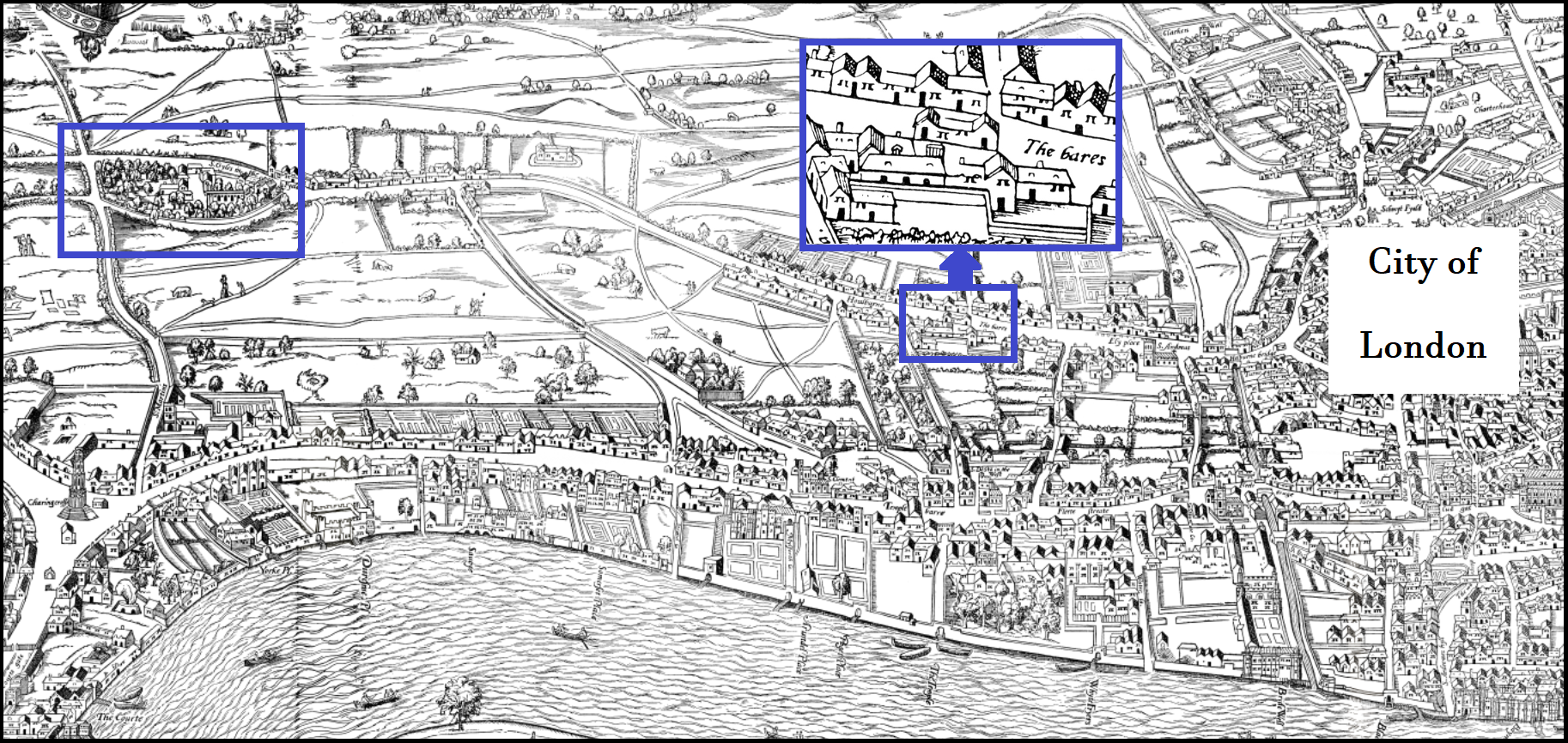
The street known to us as High Holborn was originally part of a Roman road heading west from the City to meet Watling Street at Tyburn, but the earliest record of buildings standing in the middle of it adjacent to Holborn Bars dates from 1183. In that year Richard, prebendary of ‘Holeburne’, sold the site to a religious institution, the leper hospital at St Giles less than a mile to the west. The idea was that it would provide the hospital with an income, so as part of the same contract a lease was granted to Matilda de Stoches for a rent of 9s 4d a year. Also in 1183 comes the first mention of the bars themselves – in reality, chains – stretching across the street to restrict entry into the City and aid the collection of taxes.
It is questionable even in 1183 just how desirable a location it was. True, to the west the road quickly entered open countryside, and to the east the parish church of St Andrew was conveniently close, but Matilda de Stoches also got crusader knights as neighbours: Her new rental property was separated from the Knights Templar’s first London church on the south side of High Holborn only by a long and filthy ditch known as Blose Pond. The knights were in fact on the point of moving out: Their new circular church just south of Fleet Street was completed two years later.
By 1305 the site included a forge and small shop, leased by the leper hospital to a farrier for 17s a year. Move forward a few decades, and by the mid-14th century, it consisted of one large inn, a smithy and a separate building consisting of two shops recently rebuilt. It was destined to grow much, much larger.
Land grabs: The City fails, Henry VIII succeeds
At this point Alderman Richard de Lacer of Farringdon ward in the City made an audacious attempt at a land grab, claiming the site lay in his ward. Those responsible for collecting taxes in Middlesex disagreed and sued him for twelve years’ unpaid dues, as he occupied some of the building and had refused to pay. Despite winning the support of the master of the leper hospital – which still owned the site and was, coincidentally, financially supported by the City – the alderman lost his case and had to pay up.
In 1470 the hospital master was forced to arrange the cleaning of Blose Pond, as it was ‘so blocked by the entrails of animals, dung, dead dogs and other putrefying matter that it is a danger to the health of the neighbours and passers by.’ Eighty years later the master lost responsibility for Blose Pond and, indeed, everything else as King Henry VIII seized the hospital’s assets, including the seven houses then standing in the road at Holborn Bars. These were sold by the King but by 1564 had reverted to the Crown, being referred to formally as the ‘Ground Rents’ of Queen Elizabeth I. The rents now included a narrow patch of waste ground to the west of the existing structures.
A surviving London map of this time – the Agas map of c.1560 – shows Middle Row squatting incongruously in the middle of High Holborn, happily defying all town-planning logic. The Agas map puts paid to any theory that Middle Row was a beached whale left stranded as a result of early road-widening schemes. High Holborn, it seems, was always that shape and Middle Row always stuck out like a sore thumb.
Middle Row suffers middle-age spread: More retail opportunities available
The area was becoming more urbanised. Alongside Holborn Bars to the south now sat the impressive, recently rebuilt Staple Inn, with its jettied upper floors almost touching Middle Row. This had started life as the Wool Staple, a warehouse for English wool traders in competition with the Hanseatic League, but by the end of the 14th century was occupied by trainee lawyers.
With urbanisation, development of the Middle Row waste ground was inevitable. In 1590 it was granted to trustees representing the liberty of High Holborn, who built on it the Quest House, consisting of a school room and a bootmaker’s shop on the ground floor; above, a large and well-appointed Quest Room for holding ‘inquests’ – minor legal cases of various types – and above that a garret. The block joined on to a courtyard of the existing structure. The Quest Room was still being used by Justices of the Peace as late as 1708, although by that time the ground floor was a tavern known as the King’s Head.
By 1640 the entire block was known as Middle Row, but there remained another small piece of undeveloped waste ground at the east end, and a larger plot to the west known as the Rush-Yard. A decade later the Rush-Yard had disappeared, first under a shed and then a shoemaker’s shop. The land to the east must have been built on at around the same time; Middle Row had reached its fullest traffic-disrupting potential.
On its north side the roadway was just wide enough for two carriages to pass. To the south, Blose Pond and the old Temple church were long gone and there was just space for a narrow pedestrian path between Middle Row and the buildings on the south side of High Holborn. This path was said by historian John Strype in 1720 to be ‘a place of very good trade for retailers, [such] as comb makers, cutlers, brokers, etc.’, and the houses were ‘of good quality since the rebuilding’, suggesting some redevelopment had taken place, despite the Great Fire not reaching this far west.
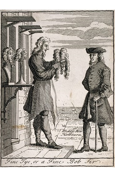
← At the time of the Agas map, Middle Row is believed to have been occupied by wig makers, and the link between place and profession continued for many years. This is an 18th century depiction of a Middle Row wig maker plying his trade.
Middle Row also became known for its taverns – Holborn, along with nearby Fleet Street and Smithfield were famous for them from medieval times. One 17th century Middle Row hostelry, the Citty of York, saw its name revived in the 1980s when the spectacular faux-Tudor pub at 22 High Holborn was renamed Cittie of York.
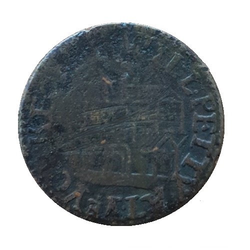
→ A 17th century tradesman’s token, a halfpenny issued by Will Petty ‘At Ye Yorke City in Midlerow’
The complaints begin
Within a century of the Agas map being produced, complaints were being made about traffic issues. James Howell, appointed Royal Historiographer to Charles II in 1660, had written three years earlier in his Perlustration of London that ‘Southward of Gray’s Inn Lane there is a row of small houses, which is a mighty hindrance to Holborn, … which if they were taken down there would be from Holborn Conduit to St. Giles-in-the-Fields one of the fairest rising streets in the world.’
In 1680 a pamphlet entitled ‘Great News from Middle-Row in Holbourn: or a True Relation of a Dreadful Ghost’ was distributed. This claimed that a recently deceased midwife, Mrs. Adkins, was seen wandering about in her former home in Middle Row, to an appropriate soundtrack of ‘impetuous groans’. Adkins then appeared before a maid-servant, belching flames of fire, and asked the terrified maid to search beneath the tiles under the hearth. What was found beneath should be buried, she added, before vanishing. The maid-servant’s employer discovered there the bones of two infants presumably hidden some years before. The implication is that Adkins had helped new mothers ‘dispose’ of illegitimate babies and in death was being forced to reveal her crimes as a warning to others. A post on the Supernatural & Natural Worlds in Early Modern Europe blog suggests another motive of the publisher – an attempt to condemn Middle Row and expedite demolition. If this is true the ploy failed, but in the coming years calls for Middle Row’s destruction would get louder even than the fire-belching ghost of Mrs. Adkins.
Evolving retail opportunities as a coffee house gets roasted
Leaving aside the ongoing traffic-flow debate, various sources give a vivid insight into the variety of Middle Row shops available to late Georgian and Victorian browsers. For example, in the later 18th century, Walter Gough is recorded as a clock and barometer maker at number 21. A clock by Gough is in the King’s collection at Kew Palace, so we’re talking quality here.
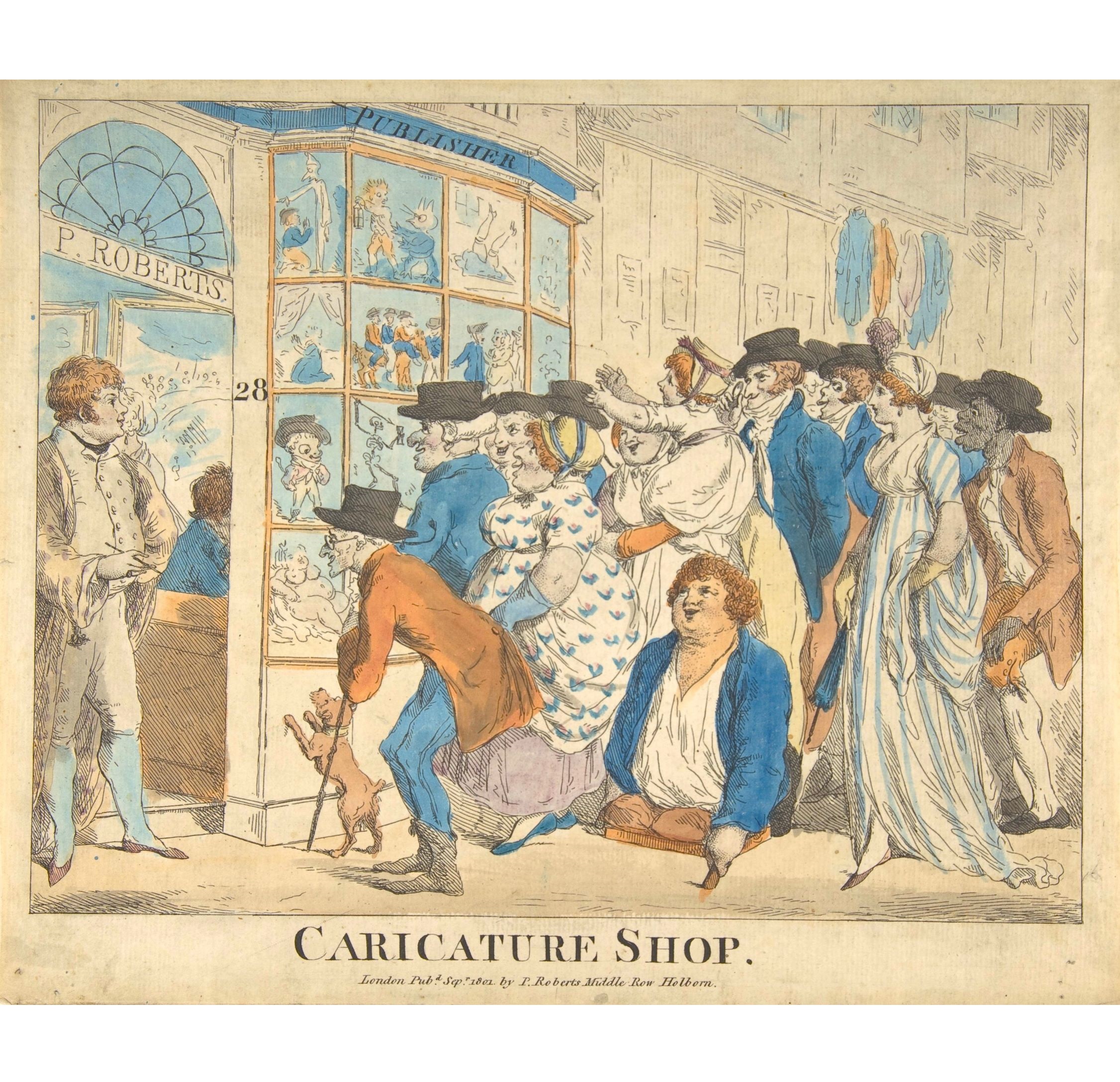
Another emporium, the caricature shop of Piercy Roberts at number 28, could happily advertise itself through its own merchandise.
← The shop of Piercy Roberts depicted in an 1801 hand-coloured etching by Mr. Roberts himself – the dapper, handsome chap on the left. No surprise there.
On the south-eastern corner, Sir James Branscombe kept a lottery-office for forty years; in those days, the places selling state lottery tickets would have been grandly decorated. Much money would also be spent on advertising that it was a lucky retailer, citing all the previous winners who had bought their tickets there. Branscombe went further: At one point Staple Inn was undergoing repairs and he had the ingenious idea of allowing the blocked pavement to be diverted through his office to get more business. A former footman to the Earl of Gainsborough, Branscombe acquired a knighthood after serving as Sheriff of London in 1806.
There were more refreshments available at Middle Row than just ale, but choices became more limited for a time from July 1834. In that month Mr. Mansfield’s coffee house at Number 14 went up in flames – twice, as the embers weren’t adequately extinguished the first time. By 1842, Robson’s street directory listed a cornucopia of retailers on Middle Row: Two taverns, two confectioners, two carvers & gilders, two stay-makers, also a ham & beef shop (delicatessen), artificial florist, hair dresser, jeweller, clothier, ironmonger, silversmith, cutler, tailor, toy warehouse, bookseller, engraver, hatter, hosier, and linen draper.
The complaints keep coming
In the early 19th century, the bar chains were replaced by simple symbolic obelisks, but the road by Middle Row must still have been prone to almost continuous congestion given the heavy traffic using such an important route. In 1816, the Commercial Chronicle newspaper proposed the demolition of ‘that absurd excrescence’, arguing that the increase in value of surrounding property would more than make up for the expense. Twenty years later Alderman Wood of the City also proposed demolition. A year after that a select committee of the House of Commons did likewise. Nothing happened. However, in 1846 circumstances finally seemed to align in favour of those wishing to see the back of the wretched Row.
This started with the sudden collapse, on the night of 2 August, of two houses. Numbers 15 and 16, presumably tired of the never-ending abuse, took matters into their own hands and waved goodbye to structural integrity. Residents had only seconds to escape. There was no loss of life but four families were left destitute; some didn’t even have the clothes they stood up in, as they weren’t wearing any. The incident was put down to heavy rain undermining foundations.
The Official Referee – an arbitrator in matters of law and officialdom – then announced that he was minded to condemn several surrounding buildings on Middle Row unless work that amounted almost to rebuilding was undertaken. The united civil parish of St George’s Bloomsbury and St Andrew’s Holborn sought the aid of the Lord Mayor to help sweep away the ‘unsightly pile of buildings’ even though the site was not in the City and thus not within his ‘magisterial authority.’ Their argument was that many dwellings pre-dated the Great Fire of 1666, were missing party walls and in a poor state of repair, and the whole thing was a fire hazard to the area, including part of the City. What they wanted was for the wealthy City to pay the cost of demolition. This was a tad optimistic; the Lord Mayor politely suggested the parish needed to contribute some of the cost itself. It couldn’t, and momentum was lost; the block was patched up, destined to stand for another twenty-one years.
But the grumbling continued. In 1856 the Holborn Committee of Works petitioned the new Metropolitan Board of Works (‘MBW’) to take action. The response was favourable: The MBW noted that High Holborn and Oxford Street between them were the key east-west axis of London and ‘the greatest thoroughfare in the metropolis’, and whereas the mean width of both was 70ft, at Middle Row Holborn narrowed to just 35ft. Consequently, it passed a motion in favour of demolition. Intent, however, is nothing without the legal means or cash to proceed and the MBW had neither. The Holborn Committee of Works tried again in 1860 and then again in 1862, this time making the astonishing claim that the narrow space was choked by 90,000 vehicles and nearly half a million pedestrians each day. The authority’s desperation was apparent, but it would not have to wait much longer. The Row’s nemesis was appearing on the horizon, and it was called Holborn Viaduct.
The end is nigh
What finally did for Middle Row was officially known as the City of London Holborn Valley improvement scheme (1863-1869), which included the construction of Holborn Viaduct and related slum clearance work. This expensive ‘flagship’ development vastly improved traffic flow along High Holborn over the valley of the Fleet river to the east, and a major impedance 400 yards further along Holborn compromising the scheme’s benefit was not to be contemplated. Revenue from coal duties redirected to the scheme finally gave the MBW the means, and an 1865 Act of Parliament the legal power, to compulsorily purchase and demolish Middle Row; the process began in September that year. A closing down sale announcement for Duncan Smith, clothier, in June 1867 started with a banner statement: ‘Middle Row Coming Down at Last!’ as if the population of Holborn still couldn’t quite believe it.
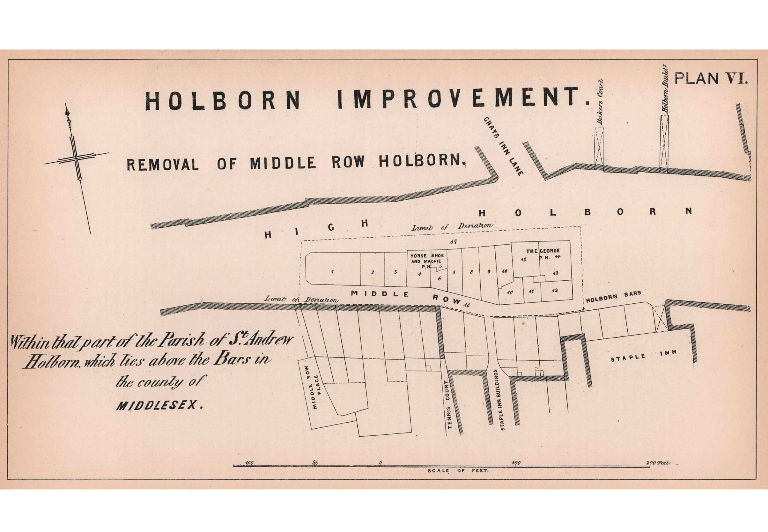
← A plan showing the ‘Holborn Improvement’ of 1867. This gives a final listing of premises numbers, which had changed frequently over the years. Continuing the great drinking traditions of Holborn, the block managed to boast two taverns until the very end, the George and the Horse Shoe & Magpie. The latter may have been the site of the earlier Citty of York.
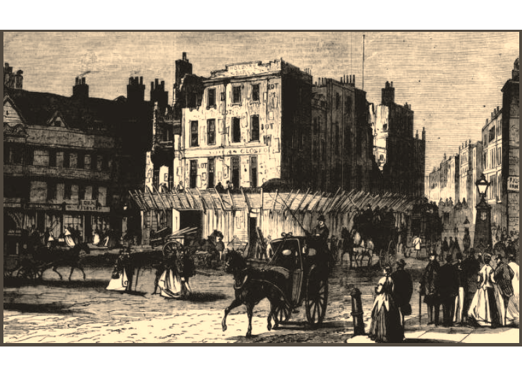
→ Demolition in progress; 700 years of history coming to an end.
Demolition began on 31 August 1867, the widened road opening in December. Unfortunately it was too wide for pedestrians to cross safely; a new traffic island was hurriedly added. New street lighting was criticised as consisting of ‘farthing rushlights’ with a letter to the Holborn Journal calling the light a monstrosity, and the Journal itself called it ‘a standing specimen of [MBW] parsimony’ .
No matter; Middle Row had, as the Clerkenwell News bizarrely put it, ‘gone like the tenants that flit without warning, down the back stair-case of time’.
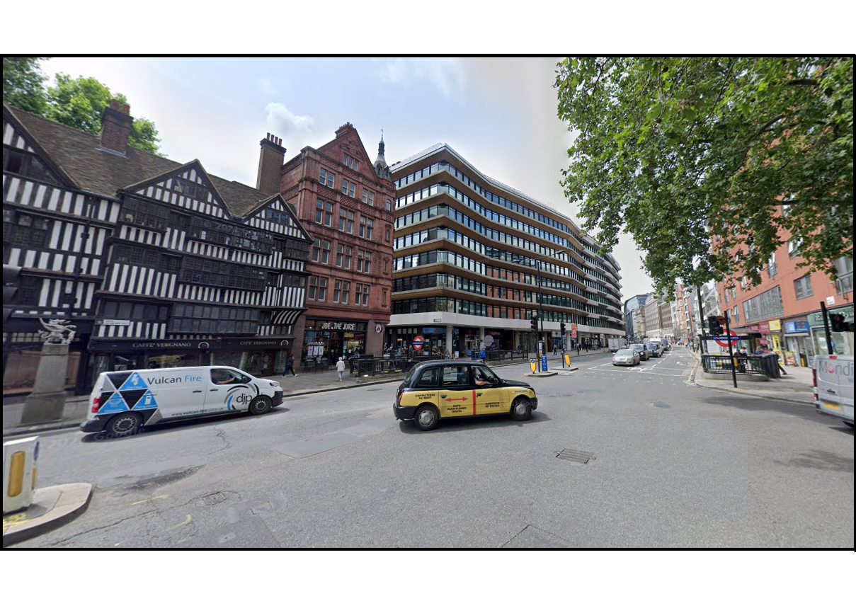
← The same view 150 years later. Staple Inn miraculously survives, though only through Victorian rebuilding behind the Tudor façade and significant post-war repairs. The silver dragon just visible on its plinth to the left denotes the site of Holborn Bars and the boundary of the City.
The modernist Holborn Gate (1974, Richard Seifert) in the centre swallowed up the last reminder of Middle Row, a small yard named Middle Row Place. Holborn Gate’s oddly-aligned frontage indicates the long-forgotten line of Blose Pond and Middle Row itself.
Postscript
Middle Row was not unique. The Daily Telegraph in 1891 remarked on ‘the fondness of our ancestors for blocking up broad thoroughfares with bricks and mortar’. Glorious names of ingloriously inconvenient developments such as Butcher Row, Pudding Island and Newgate Shambles still echo down through the years despite being consigned to history long before Middle Row. But the Telegraph story highlighted one still standing – Holywell Street – and the grand plans to construct a huge boulevard between Holborn and the Strand driving straight through it. These plans would come to fruition a decade later as the Aldwych-Kingsway scheme. The journalist even dared suggest the scheme should include the demolition of St Mary-le-Strand and St. Clement Danes, two churches that would otherwise be left stranded mid-Strand. Thankfully, they were left to hinder the traffic of future generations – sometimes progress can be taken too far.
Nearest Station: Chancery Lane
Selected Bibliography:
Credits: