
If I mention parish almshouses, what probably springs to mind is a vision of idyllic cottages in a pretty village, with gardens lovingly tended by elderly residents living out their twilight years in modest comfort. Indeed, my home borough of Waltham Forest has several examples that come close to this vision. But what if the parish was one of the most deprived districts of central London?
St. Giles-in-the-Fields ceased to be in fields by the mid-17th century; in their place, the unstoppable spread of the metropolis created an urban district of mainly poor neighbourhoods. Like any parish, St. Giles had respectable elderly residents of limited means deserving of charity, and almshouses were one solution. Unfortunately, the good burghers of St. Giles were adept at choosing appalling locations for theirs, rivalling Dick Whittington in this respect. The famous Lord Mayor had, in the early 15th century, funded almshouses directly above his vast Walbrook public lavatory. This WC had 120 seats, flushed only twice a day by the Thames. Truly the (alms)house at Pooh Corner.
But I digress. The first St. Giles almshouses were built in 1656 on land donated by the Earl of Southampton. The drawback was that they stood in the centre of St Giles High Street – literally. The five two-roomed homes for aged widows were erected in the middle of the road, on a site previously occupied by the parish cattle pound. This unaccountable choice inevitably led to the buildings impeding traffic, and it is perhaps surprising they survived as long as they did. The site was finally cleared 126 years later, and the vestry – parish council – provided replacements to house twenty women on a small site to the east, on Lewknor’s Lane.
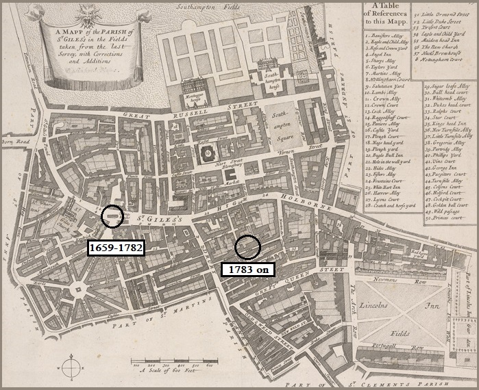
This street was another bizarre choice, and its history before the almshouses arrived is worth recounting. Named after an earlier resident, Sir Lewis Lewknor, by 1633 it was described as the ‘backside of Drury Lane’ and it was downhill from there. In the great plague year of 1665, Lewknor’s Lane was the epicentre, and arguably the origin, of the whole outbreak; it should therefore rank with Pudding Lane in the annals of London disasters. Speaking of Pudding Lane, the following year the Great Fire – which left St Giles unscathed – led to an influx of refugees and more overcrowding. The parish at this time has been described by modern authors as ‘hell on earth’ (Lehman) and ‘notoriously poor, filthy and dangerous’ (White). Over the following decades it became home to many of the poorest members of groups on the edge of London society- Irish immigrants, lascar sailors and eastern European Jews. Particularly notorious were the precincts of Seven Dials and the most infamous and lawless slum of all, the St. Giles Rookery.
Just to the east of these areas, Lewknor’s Lane continued its downward spiral, becoming host to houses of ill-repute. A petition to the Countess of Castlemaine – a former prostitute herself – on behalf of ‘poor whores, bawds, pimps and panders’ appealed for protection against riotous apprentices, and was signed by Lewknor’s Lane brothel-keepers. The lane had officially been renamed Charles Street by 1722 in a vain attempt to lose its atrocious reputation, but was still widely known by its old name when, in 1728, it appeared in The Beggar’s Opera. The insatiable MacHeath sends for women from ‘Hockley in the hole … Vinegar-Yard and … Lewkner’s-Lane’. It was so notorious as a centre of vice that it was known variously as Dirty Lane and Little Sodom.
It was in this choked, filthy and disreputable backstreet that, in 1783, the poor widows took up residence in their new almshouses. These were simple two-storey terraced homes facing each other across a narrow alleyway. The main exit may have been north through Coal Yard, now Smart’s Place, reputedly the birthplace of Nell Gwyn. The address of the almshouses was frequently – but not always – referred to as 10 Smart’s Place in later years.
From this moment on, trouble was never far away, although the first problem came from an unlikely source. The almshouses were engulfed in a financial crisis in 1814, when it was discovered that the charity running them had not kept proper accounts. Funds were rapidly running out, so an appeal was made to the residents of this chronically poor parish. Surprisingly, this seems to have been a remarkable success and the almshouses returned to a sound financial footing.
The almshouse site itself had been described as ‘close and unhealthy, surrounded with buildings of the lowest description’ . Those surrounding buildings continued to decay over the decades, to such an extent that in 1841 parish officers demanded the immediate demolition of unsafe parts of three Charles Street houses. The remaining parts, left empty, were considered fair target for thieves. It turned out they were also perilously unsafe. While the asset-stripping was under way, numbers 14 and 15 collapsed completely, killing two of the thieves – a jobbing bricklayer and a 13-year-old boy, both residents of the street. At around this time, even more people were pouring into the area, displaced as the Rookery was swept away by the construction of New Oxford Street.
There was a more positive development in 1857. It took seventy years from the construction of the almshouses for their residents to get even one respectable and structurally-sound neighbour, but finally the Roman Catholic school of St Joseph was built across the road, with both monks and nuns. Another school arrived at around the same time. This was the ragged school and soup kitchen, serving children of the very poorest families, and always in need of funds. An 1871 appeal had the president of the school describing its location as ‘the worst street in the worst part of St. Giles’. It was later replaced by the Drury Lane Board School almost directly behind and adjacent to the almshouses, in Coal Yard.
A close shave came in November 1868, when the widows of the almshouses were threatened by Widow Twanky: The nearby theatre scene-painting establishment of Grieves went up in flames, the fire made worse by the approaching pantomime season, the premises full of scenery being prepared for Christmas extravaganzas. Mr. Ruthven, the resident overseer at the almshouses, was praised for evacuating the residents who at one point were in great danger. Leading 25 elderly ladies and his own family to safety must have been quite an achievement.
By 1878 the name Charles Street was so notorious that, with a final application of porcine lip-gloss, the road was renamed again. This time it became Macklin Street, after Charles Macklin (1699-1797), an Irish actor associated with the nearby Theatre Royal Drury Lane. He was famed for his natural style of acting and, more ominously, for stabbing another actor to death in an argument over a wig.
Once again, renaming achieved little. Perhaps taking their cue from Macklin’s violent past, the residents managed to maintain the street’s appalling reputation. In 1882, newspapers reported a riotous fight in the street resulting in two women being arrested with the greatest difficulty. Both appeared in court heavily bandaged around the head. One, Catherine Day, had two black eyes, through which she could hardly see, and her mouth was so swollen she could scarcely make herself understood. The pair were fined. Six years later, a young resident, John McCormack, was found guilty of inciting riot and using threatening and abusive language while speaking in Hyde Park – he had suggested that Queen Victoria should be doing her own washing. He was also fined, and thus proved that there really were limits on what could be said at Speaker’s Corner.
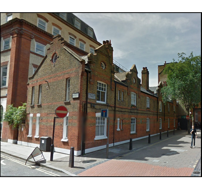
The almshouses were reconstructed in 1885 on a slightly enlarged site, to designs by Edward Henry Burnell in a domestic Jacobean style. This cost around £320,000 in today’s terms but reduced the number accommodated to ten. However, there was room for a matron, and a small pension was extended at this time to a number of ‘out pensioners’ – those not living on site. The decision not to move the almshouses to a more pleasant location was condemned: Local historian Walter Blott suggested a decade later that the new structures were ‘cheerless homes’ in a ‘foul cul-de-sac’.
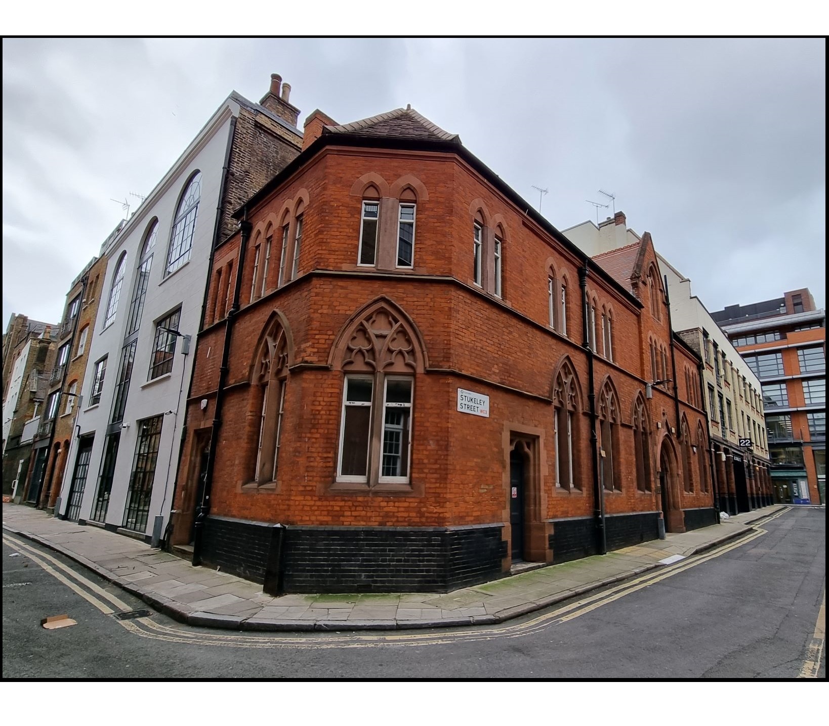
Meanwhile, just a few yards along the road, an appropriately Gothic coroner’s office and mortuary was opened, complete with fully equipped post-mortem room in the attic. It is not recorded what the almshouses’ elderly residents made of this new temple-of-death on their doorstep.
→The former coroner’s office and mortuary, on the corner of Macklin Street and Stukeley Street.
The mortuary may at least have been smart and well-built; but the demolition of a cowshed opposite sadly did little to improve matters, as it was replaced by the St. Giles Casual Wards. This factory-like structure provided accommodation for vagrants – legally called casual paupers – and was run by the infamous St Giles Workhouse nearby. In October 1887, the Globe newspaper contained an article describing those who had sought a bed there the previous night. The article explained that any woman seeking a bed would be seen first; that anyone drunk was refused entry, as was anyone who had secured a bed there any night in the last month. A Scot was refused a bed because he had almost a shilling on him and was therefore not a pauper in the eyes of the law.
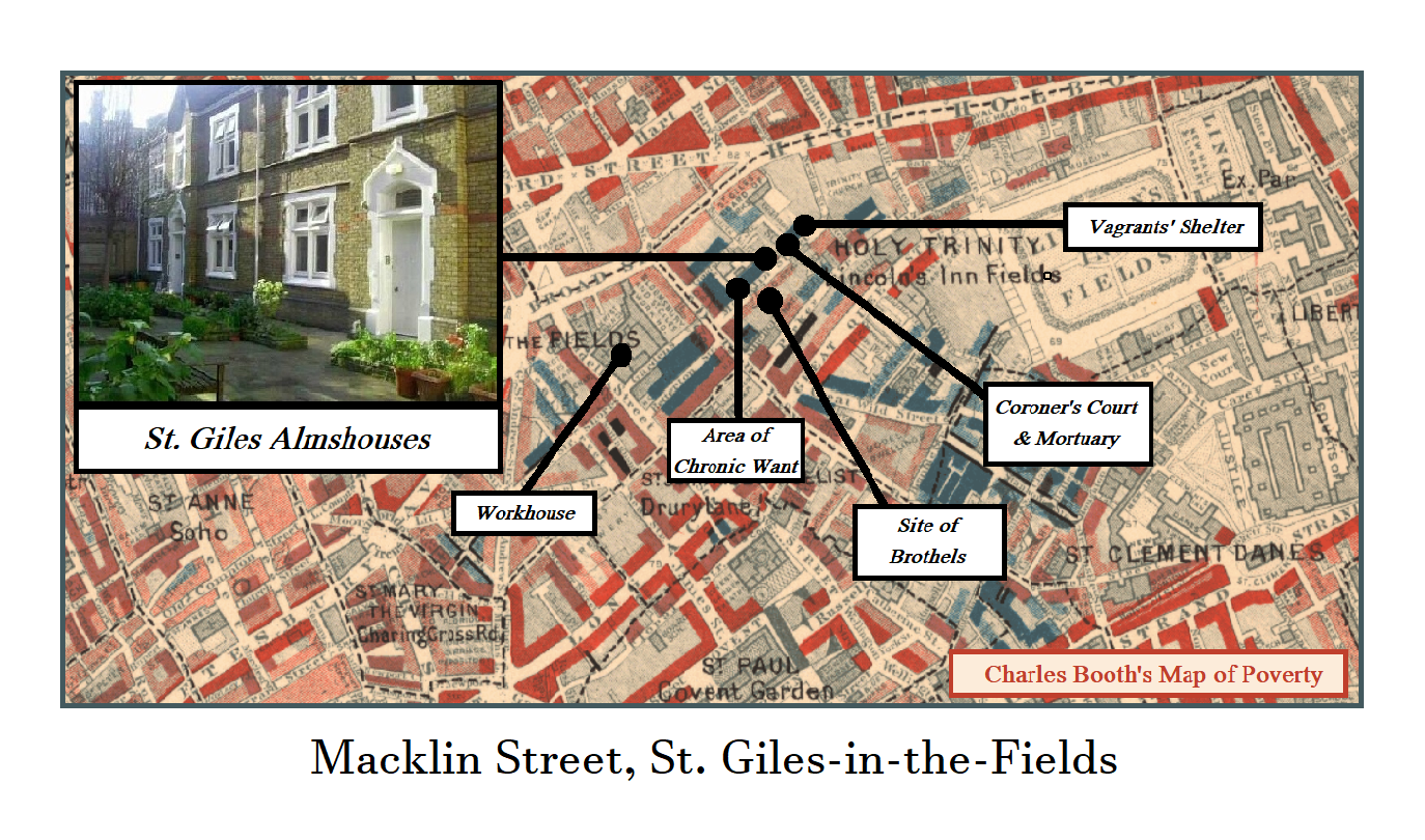
At around this time, Charles Booth’s famous poverty map of London revealed much of the neighbourhood to be an area of ‘chronic want’. Insurance maps of 1888 show that between the new developments, the street was full of common lodging houses – where a bed for the night would cost no more than fourpence – and decaying, overcrowded tenements. Thankfully, further improvements were on the way.
←The Macklin Street entrance to the courtyard, showing the 1885 almshouses beyond. There is no proper view of the attractive frontages from any street. The Victorian wall seems to be a barricade against other Macklin Street residents.
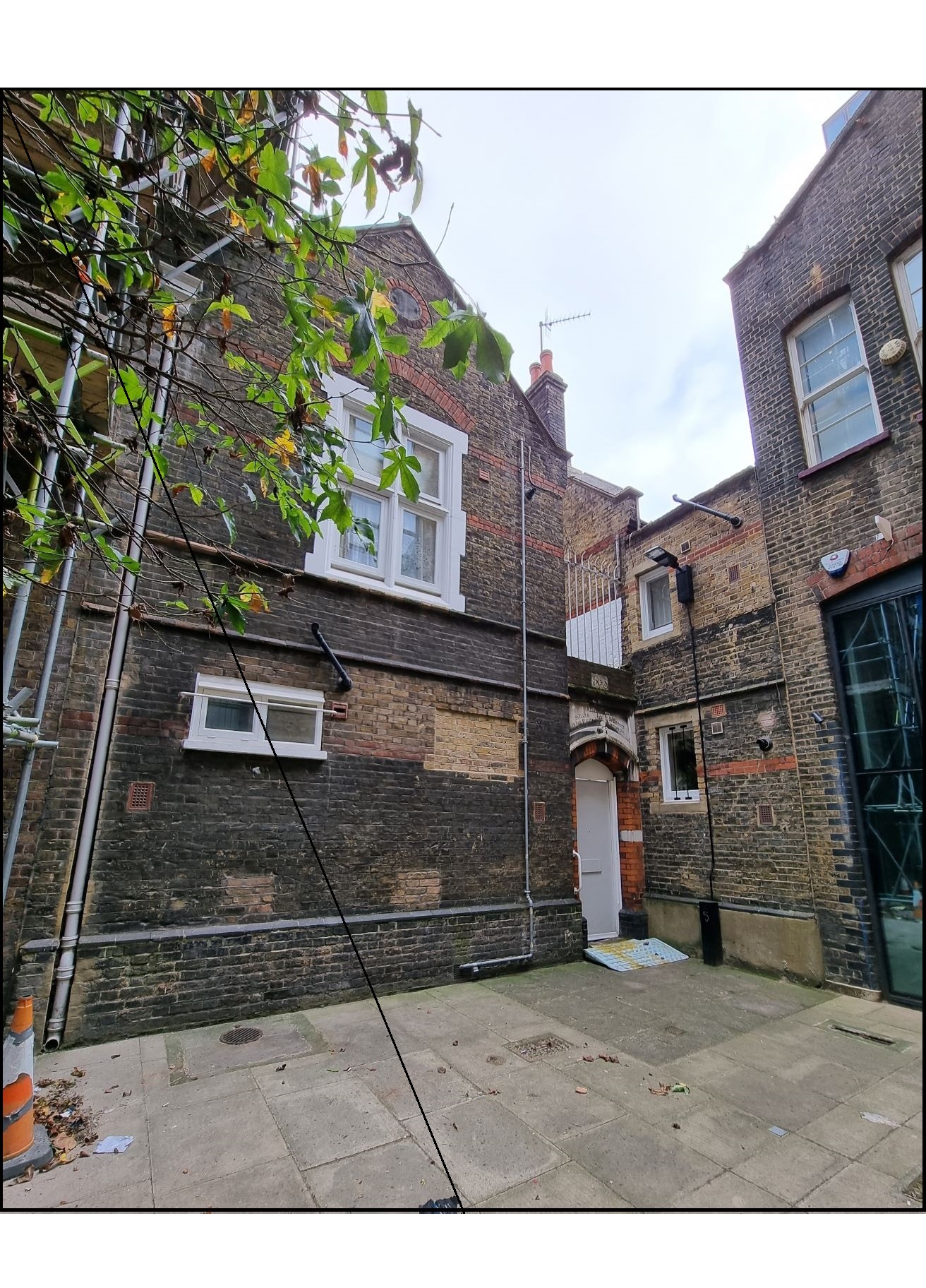
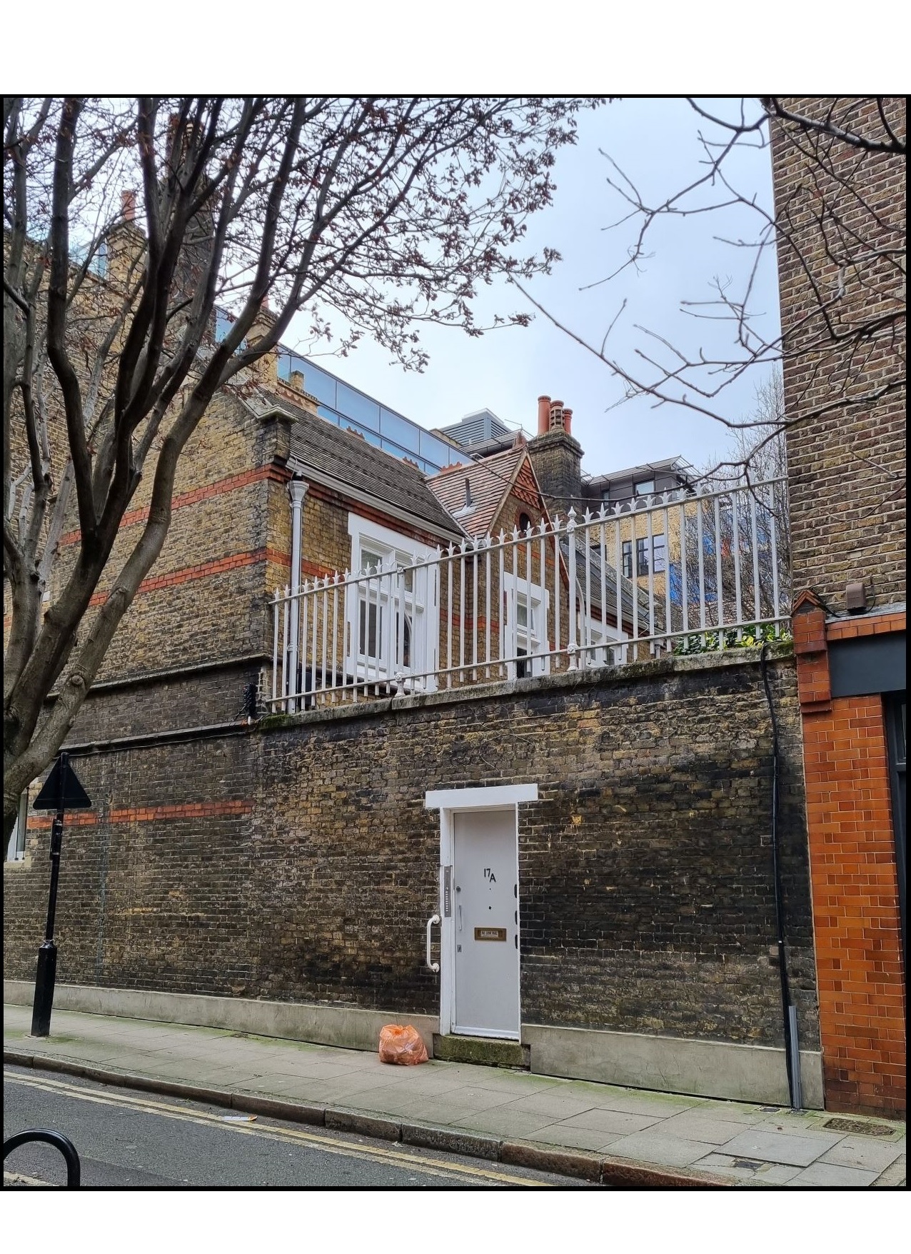
←The entrance from Smart’s Place, showing the side of the north block to the left of the entrance. This may have been the ‘foul cul-de-sac’ described by Walter Blott.
↓ A close-up of the inscription above the door.

Blocks of artisan lodgings, quite advanced for their time, were started in 1889 by the new London County Council (‘LCC’). This was the LCC’s first large-scale building project. With the whole of inner London to choose from, it shows how urgent the redevelopment of Macklin Street had become. Unfortunately, the project couldn’t rehouse all the people it displaced. One cause was the chronic overcrowding. Another was ‘ancient lights’ – the right of buildings over 20 years old to keep their daylight. Hansard, a printing company, occupied one such building in the next street, and was determined its rights be upheld. This meant that one of the new blocks, Wimbledon Buildings, could only be built to a height of two stories. It is, as a result, unexpectedly charming and almshouse-like. The LCC blocks, along with another built by the Society for Improving the Conditions of the Labouring Classes, managed to lift the area out of the gutter. Even St. Joseph’s School joined in, rebuilding on an enlarged site in 1908 to avoid being closed down by authorities.
← Wimbledon House, as it is now called, at the east end of Macklin Street. The successor building to Hansard looms over it, enjoying those ‘ancient lights’ that prevented Wimbledon House from being any taller.
After this burst of activity, Macklin Street barely changed over the next eighty years. In 1939 there were nine female pensioners on site, with a matron and secretary. Neither Blitz nor post-war redevelopments impacted the almshouses or the road on which they sit. Macklin Street is still not attractive, but surviving tenements from the LCC building spree, along with the school and former mortuary lend some charm, and the architectural mix is interesting. Of course, there have been some changes. In particular, the casual wards, closed by 1920 through lack of demand after the First World War, and later used as industrial units, came down in the 1970s. At the western end, the demolition of the Winter Garden Theatre on Drury Lane and its replacement with the much larger New London Theatre complex brought 1970s architecture to the south side. Aside from residential blocks, there are now boutique print works, design studios, office space for start-ups and similar businesses.
Amid this slow evolution, the almshouses remain. They are the only ones left in the centre of London and sit, fortress-like, behind their large Victorian wall that seems determined to keep the sins of Macklin Street at bay. The tiny, pretty communal courtyard contains a single tree and a stone tablet commemorating the 1885 rebuild, and is the setting for an annual summer tea-party hosted by St Giles-in-the-Fields parish church. Various upgrades over the years, most recently in 2019, have left the almshouses consisting of eight one-bedroom apartments with all necessary mod-cons but no onsite matron. They are managed by the small St. Giles-in-the-Fields and Bloomsbury United Charity, an amalgamation of several ancient bodies of the combined parish of St Giles and St George’s Bloomsbury. Ironically, it owns the former mortuary which is now office space rented out to provide an income. In 2022, it seems the former guest-house of the dead helps pay for the homes of the living.
Nearest Station: Holborn
Credits:
Selected Bibliography: